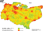
 click it to big itDear reader, those nice people at the CPRE have produced some maps that are both pretty and informative. They show the distribution of "Tranquility" across our fine nation, and come with an explanation of how the CPRE assess tranquility.
Looking at the map of Kent (click it to big it) the cities and towns are easy to spot, as is the M20 running through Ashford to Folkestone, and the roads radiating out from Canterbury.
Looking more closely at North-east Kent, it's easy to spot Whitstable, Herne Bay, Birchington, Westgate, Margate, Broadstairs, Ramsgate and Canterbury.
 But what's that red smudge of non-tranquility, just west of Ramsgate and south of Westgate? An all-night rave at Acol? Burning the candle at both ends in Minster? Innumerable painted lady butterflies smashing their wings together? Countless ladybirds crashing about like tiny scarlet castanets?
Nope. It's everyone's favourite neighbour: Kent International Airport at Manston. Even with the current ("unsustainable") low level of traffic, they have as much impact on the quality of life as a small town. By way of reminder, dear reader, the airport's strategy is to achieve 103,800 flights a year. Equivalent to one every 5 minutes, day and night, all year. You may as well fish out your favourite crimson lippy and colour in all the rest of Thanet scarlet.